Press Release From The JIS
The National Land Agency (NLA) is utilising drone technology to enhance the services it offers to the public.
In 2018, the NLA commenced acquiring unmanned aerial vehicles (UAVs), or drones, to aid in its photogrammetry activities.
Since then, the agency has explored the possibility of expanding the technology’s utilisation in other areas of its operations.
The use of UAVs has spurred improved efficiency and accuracy in surveying and mapping activities and has proven cost-effective for a number of NLA’s departments.
The Photogrammetry Department, for example, previously relied on aerial photographs acquired by airplanes and helicopters for use in its measurements and 3D rendering.
“In this instance, we are now using these drones to do special purpose mapping on our own; and we are able to do smaller projects on our own and as needed. So, it is not as expensive as what obtained before; and so it has transformed the workflow,” Supervisor for Topographic Data Management at the NLA, Chaplin Williams, shared with JIS News.
He also highlighted that the drones reduce the time surveyors spend conducting surveys, while improving the survey grade accuracy.
“Whereas they would spend a number of days or maybe months doing a particular survey, we are able to cut that down to days or weeks now, because we can fly within a particular area and acquire the imagery along with other information, such as elevation-type information. So, we’re able to get more imagery and features on the ground, within less than a metre, accurate,” he added.
Additionally, accessibility to land through the UAVs has improved the accuracy and value of the data collected by the NLA, particularly in areas where the agency’s land valuation team is unable to physically access a property.
Mr. Williams shared that consequent on imagery and data collected from drones, land valuators can view a property from various angles, get precise measurements of buildings, see the variety of flora present, and properly record the terrain and features of the land to give accurate valuations.
To effectively incorporate UAV technology into its operations, the NLA engaged the Caribbean Maritime University to impart customised drone pilot training for its officers.
Manager of the Mapping Services Branch in the Surveys and Mapping Division of the NLA, Milton Saunders, said this was well received by participants, who are engaged in continuous learning of the new technologies.
“The expertise of the staff grew… when they made use of the devices out in the field. Upon purchasing each device, we are exposed to some amount of training from the local dealer; so that also helps,” Mr. Saunders noted.
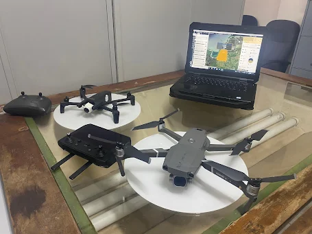
The devices used by the NLA include a Parrot Anafi quadcopter drone; a senseFly eBee X fixed wing drone; DJI Mavic 2 Pro drone; and a WingtraOne Gen II drone.
Along with the drones’ proprietary software, the NLA uses geographic information systems (GIS) software to incorporate drone-captured data into usable end products, such as cadastral and topographic maps.
These additional inputs include the Drone2Map, provided by international GIS software supplier - Esri, and Pix4D.
A section of May Pen in Clarendon, taken with the National Land Agency’s WingtraOne Generation II drone.


That is very good
ReplyDeleteWay to go NLA
ReplyDelete